Free, open-source territory map for freight and industrial sales reps
Territory Atlas
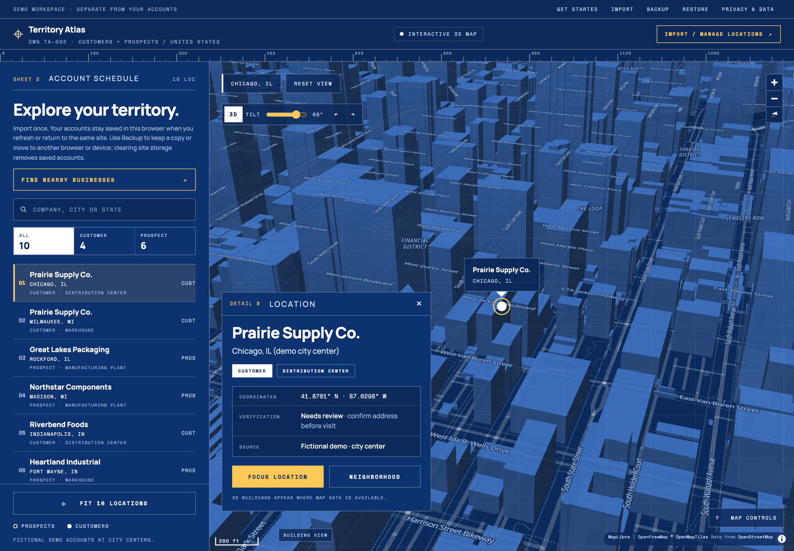
See where your customers are on a map, then search around your book of business for other prospects. It runs in the browser with no account and no application backend.
Source on GitHub (opens in a new tab) territory-atlas.pages.dev (opens in a new tab)
The problem
A rep's book of business lives in a spreadsheet. There's no quick way to see where those customers are, or to find other businesses near them worth prospecting.
My role
Creator and maintainer. I built it for my own territory, then opened it up as a public tool, set the privacy and data rules, and built it with AI coding assistants.
- Spotted
- I wanted a visual of where my customers are located, so I built a map of my book of business. Then I added a layer to search around those accounts for other prospects, and later opened both up for other freight and industrial reps.
- Decided
- Make it free and open source, and keep customer lists out of anyone's servers: no sign-up, no upload, no analytics. People bring their own TomTom key, so the project carries no shared cost and never holds anyone's customer list.
- Built
- Spreadsheet import with a row-by-row review, 2D and 3D maps, drawn search areas, browser backups, a fictional demo workspace and automatic publishing from GitHub, working with AI coding assistants.
- Learned
- A tool can't promise more than its data supports. Imports sit at city centers marked Needs review, and TomTom results stay preview-only until saving them is confirmed as permitted. I drafted a permission request rather than quietly saving them.
What changed
Documented changes to the product, not measured customer results.
- Before
- My own tool: a map of my customers plus a prospect-search layer, holding real account data.
- Now
- A public, MIT-licensed project at territory-atlas.pages.dev with a demo workspace of fictional facilities, so anyone can try it without their data.
- Before
- Built around one territory: mine.
- Now
- Any rep can import a CSV or XLSX book of business with a row-by-row review, back it up, and search a circle up to 100 miles or a freehand area with their own TomTom key.
What it does today
- CSV and XLSX import with a row-by-row review; duplicates and invalid rows are skipped
- 3D map (MapLibre) and 2D map (Leaflet) views, with a demo workspace of ten fictional facilities
- Circle and freehand area drawing with keyboard-operable handles
- Nearby-business search with the user's own TomTom key; results are temporary previews
- Accounts saved locally in the browser, with backup and restore as JSON
Decisions and tradeoffs
- Local-first by design: no analytics, no account sync, and no upload endpoint for customer data.
- The README states which external requests still happen (map tiles, optional address lookup, optional TomTom search) rather than implying none.
- Imports are placed at city centers and marked Needs review until a facility is verified.
Scope & limits
- Visit scheduling, driving routes and shortlist export
- Saving or exporting search results
- Company-level grouping of facilities
How it was built
I build with a range of AI coding tools and agents, then test the result against the workflow it is meant to improve. The stack is listed for reference.
- React
- Vite
- MapLibre GL
- Leaflet
- Cloudflare Pages
- GitHub Actions
Source: the project's own README and documentation, checked October 21, 2026.